TUSAYAN FIRE DISTRICT
"Providing First Class Service To One Of The 7 Natural Wonders Of The World"

Call Us: (928) 638-FIRE
Local Hiking Trails and Area Maps
Tusayan Fire District Boundary

Kaibab National Forest Boundary

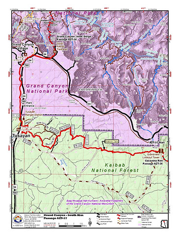
The Arizona Trail - Passage 37
The Arizona Trail is an 800+ mile recreation trail from Mexico to Utah that connects mountain ranges, canyons, deserts, forests, wilderness areas, historic sites, trail systems, points of interest, communities, and people. It serves dayhikers, backpackers, equestrians, mountain bicyclists, trail runners, nature enthusiasts, cross-country skiers, snowshoers, and mule and llama packers.
Passage 37 of the Arizona Trail travels through the Tusayan Ranger District of the Kaibab National Forest and offers opportunities to view a variety of vegetation types -- from ponderosa pine and Gambel oak to pinyon-juniper, sage and grasslands. The trail also offers some tantalizing views of the San Francisco Peaks, Grand Canyon, Upper Basin, Coconino Rim and the Painted Desert.
For several months of the year, there may be no water sources along these segments. Russell Tank, the most dependable water supply, is a very important source for wildlife and livestock. All water sources should be considered unsafe for human use unless properly treated.
The Arizona Trail runs from the southern boundary of the Tusayan Ranger District north and northwest to Grandview Lookout Tower. Then, the trail heads west from Grandview to Tusayan. From there, the trail exits the Tusayan Ranger District and enters Grand Canyon National Park.
For more information regarding the Arizona Trail, please visit:
https://www.fs.usda.gov/recarea/kaibab/recarea/?recid=11691
Tusayan Trails
Because Tusayan is located in one of the nation's largest ponderosa pine forests, all the trails provide an excellent opportunity for viewing wildlife such as elk, mule deer, hawks, eagles, pronghorn antelope, rabbits, coyotes, turkeys and many species of birds. Please remember these are wild creatures. Help them stay wild and do not approach or feed them.
Tusayan Greenway Trail is a 6.6-mile one way trail that goes from the parking lot just west of the north roundabout to the rim of the Grand Canyon near Mather Point. This is a maintained paved/gravel trail suitable for hiking, biking, or horseback riding. A National Parks Pass is required to enter the Grand Canyon even by foot, so make sure to purchase a pass ahead of time.
Tusayan Forest Trails consists of the Tusayan short loop at 4.4 miles and the Montane long loop at 7.3 miles. Both trails can be accessed just a little north-east of the south roundabout or from the Tusayan-Montane Campground. These are moderate difficulty trails and are suitable for hiking and biking.

